MML - Flood
Flooding is one of the most damaging natural disasters we face—and with climate change, the risks are only growing. In our latest research, we’ve developed a machine learning model that combines different types of data—like geographic information and past disaster records—to predict where floods are likely to happen over the next 1 to 5 years. By using both text and numbers together, our model performs significantly better than traditional methods, reaching up to 77% accuracy. It’s a step forward in using AI to plan ahead and reduce the impact of natural disasters.
Nicole Zhang & Zein Mukhanov
7 min read
Why Floods Are Getting Harder to Predict — and Why That Matters
In 2022, catastrophic floods covered a third of Pakistan, affecting 33 million people and causing over $30 billion in damages. Events like this are becoming more common — and harder to predict — as the climate crisis accelerates. While today’s models help us prepare for floods a few days in advance, what if we could look years ahead?
Our research explores that possibility. We built a multimodal machine learning model that uses not only historical flood and weather data, but even geographical descriptions from Wikipedia — yes, the same website we all use to check random facts! The goal? Help cities, insurers, and global planners see what areas might be at risk years in advance — so we’re not always caught off guard.
Current Models Can't See That Far Ahead
Think of most flood models like short-term weather apps. They can give you great forecasts for the next 3–5 days, maybe a bit longer if conditions are stable. But ask them what might happen in two years? They go silent. Why? Physical hydrological simulations break down the further into the future you go due to compounding uncertainties.
That’s a huge problem for urban planners, climate adaptation strategies, and global finance. Floods don’t just damage homes — they disrupt supply chains, destroy infrastructure, and destabilize entire regions. Governments and insurers need models that can anticipate risks with enough lead time to invest, plan, and protect. Machine learning, with its data-hungry appetite and pattern-finding ability, offers a new path forward.
Our ML model (1–5 year classification with 75–77% accuracy)
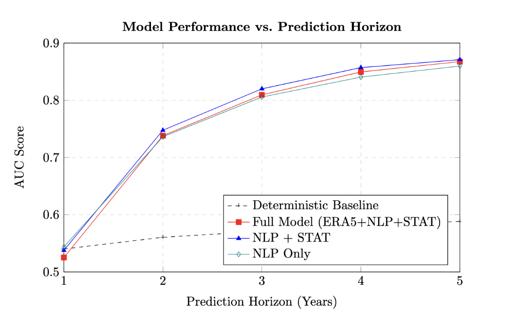
Area Under the Curve (AUC) scores for different model configurations across 1- to 5-year prediction horizons. The performance is compared against a deterministic baseline (black dashed line), highlighting the significant predictive lift provided by the machine learning approach for horizons greater than one year.
Teaching AI to Understand Flood Risk
We trained our AI to predict whether a 1°x1° region (about the size of a small state or province) will flood within the next 1 to 5 years. What makes our approach special is that we didn’t just give it numbers — we gave it stories. Here's what we mean:
- Geographical Text: We scraped Wikipedia’s “Geography” sections for each location — this gives the model natural-language descriptions like “low-lying coastal plain” or “prone to monsoon rains.”
- Statistical Features: From GDIS and EM-DAT datasets, we pulled data on past disasters like floods, earthquakes, storms, and their severity, frequency, and damage costs.
- Grid-Based Modeling: Each region is treated as a “cell,” and the AI learns features for that cell based on both structured and unstructured inputs.
We then used XGBoost to predict binary outcomes (flood or no flood) over different horizons, and tested different variations of how the text was processed (e.g. fine-tuning vs transfer learning on DistilBERT).
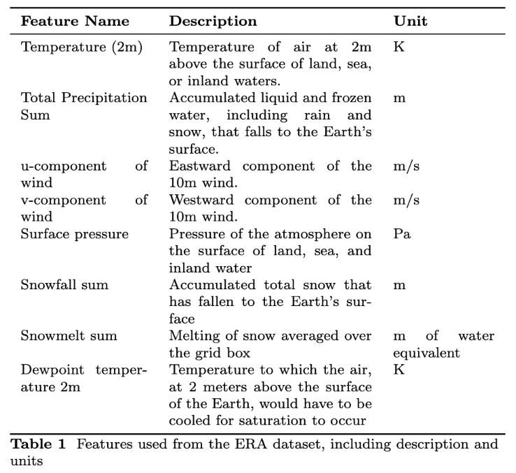
Table of weather features (like temperature, precipitation, snowmelt)
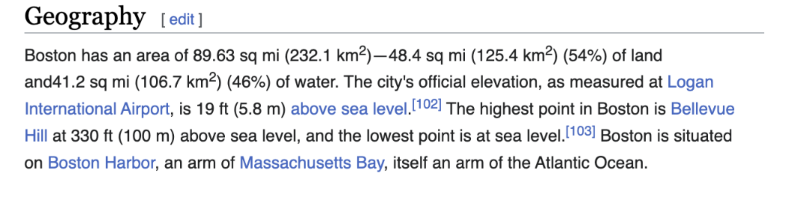
Screenshot of Wikipedia’s Geography section used for Boston
What Makes This Approach Different?
Let's break this down clearly:
- Global Coverage: Most models focus on a city, watershed, or country. Ours spans 2,800+ grid cells across the globe.
- Multi-Year Forecasting: While hydrological modvisuels do well with 1-week predictions, ours targets 1, 2, and 5-year horizons — supporting planning, not just reacting.
- Multimodal Learning: We go beyond tabular data and plug in textual embeddings from Wikipedia. It’s like teaching the model how to “read” a region.
This multimodal approach is inspired by how humans reason: we don’t just look at numbers – we interpret stories, topographies, and past patterns. Our model does the same, just at scale.
Results: Can AI Actually Do This?
Yes — and better than you might expect.
Our best-performing model hit a 77% ROCAUC score when predicting 5-year flood risks — a strong result in such a noisy, real-world problem space. Compared to simple baselines (like "just assume if it flooded before, it’ll flood again"), we see ~42% relative improvements in AUC and 25% in balanced accuracy.
This tells us two things:
- ML can identify patterns beyond simple heuristics.
- Textual features - often overlooked in climate models - really matter.
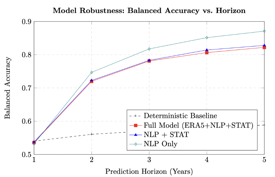
Balanced Accuracy scores across 1- to 5-year prediction horizons. This plot confirms the trend seen with AUC, showing that the ML models, particularly those using NLP features, becomevis substantially more robust than the baseline for longer-term forecasts.
It's not perfect - yet!
Every model has limitations — and we’re upfront about ours.
- Some regions lack enough historical data, which makes predictions harder.
- Wikipedia coverage is uneven; rural areas may have sparse or vague descriptions.
- The weather and disaster data we use lag by several months, limiting real-time applications.
That said, our goal isn’t perfection — it’s progress. We're already working on expanding the model to other disasters (like wildfires and droughts) and enhancing its real-time relevance. Long-term, we hope this kind of framework can be plugged into city planning, insurance risk analysis, and climate resilience programs.
Big Picture: Planning for the Future, Not Just the Next Storm
Imagine if cities, insurers, or governments could know which regions are likely to flood — not tomorrow, but next year.
Imagine a world where city planners can ask: “What regions will likely flood in the next 5 years?” and get a probabilistic answer from a robust, data-driven model. That’s the future we’re working toward.
AI won’t stop the floods. But it can give us the tools to plan better — to reinforce levees, adjust land use, set insurance premiums, or relocate vulnerable communities. In an era of increasing uncertainty, that kind of foresight is priceless.
This is more than a research project → it’s a proof-of-concept for how AI can help us adapt to a changing climate.